Geolocate

Browns Island topographic map

Interactive map

Click on the map to display elevation.

About this map

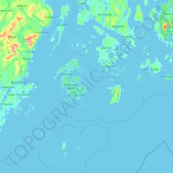
Name: Browns Island topographic map, elevation, terrain.

Location: Browns Island, Knox County, Maine, USA (43.76036 -69.09670 44.40036 -68.45670)

Average elevation: 49 ft

Minimum elevation: -7 ft

Maximum elevation: 1,322 ft

Other topographic maps

Click on a map to view its topography, its elevation and its terrain.

Crooked River

USA > Maine

Crooked River, Oxford County, Maine, 04217, USA

Average elevation: 741 ft

Bryant Pond

USA > Maine > Bryant Pond

Bryant Pond, Oxford County, Maine, 04255, USA

Average elevation: 886 ft

Fisherman Island

USA > Maine

Fisherman Island, Washington County, Maine, USA

Average elevation: 0 ft

East Island

USA > Maine

East Island, Somerset County, Maine, USA

Average elevation: 138 ft

Midway Island

USA > Maine

Midway Island, Kennebec County, Maine, USA

Average elevation: 351 ft

Ellis River

USA > Maine

Ellis River, Oxford County, Maine, USA

Average elevation: 781 ft

The Anvil

USA > Maine

The Anvil, Hancock County, Maine, 04613, USA

Average elevation: 46 ft