
Beni Khiar topographic map
Interactive map
Click on the map to display elevation.
About this map
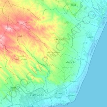
Name: Beni Khiar topographic map, elevation, terrain.
Location: Beni Khiar, Nabeul, Tunisie (36.44936 10.68577 36.59671 10.83582)
Average elevation: 230 ft
Minimum elevation: -10 ft
Maximum elevation: 853 ft
Other topographic maps
Click on a map to view its topography, its elevation and its terrain.
Dar Chaabane El Fehri
Dar Chaabane El Fehri, Nabeul, Tunisie
Average elevation: 361 ft
Menzel Bou Zelfa
Tunisie > Nabeul > Menzel Bou Zelfa
Menzel Bou Zelfa, Menzel Bouzelfa Sud, Menzel Bouzelfa, Nabeul, 8010, Tunisie
Average elevation: 154 ft
Bir Challouf
Tunisie > Nabeul > Bir Challouf
Bir Challouf, Neapolis, Nabeul, 8000, Tunisie
Average elevation: 49 ft