
Catharinau topographic map
Interactive map
Click on the map to display elevation.
About this map
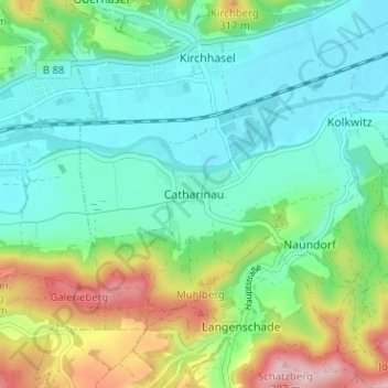
Name: Catharinau topographic map, elevation, terrain.
Average elevation: 787 ft
Minimum elevation: 587 ft
Maximum elevation: 1,276 ft
Other topographic maps
Click on a map to view its topography, its elevation and its terrain.
Am Luisenturm
Deutschland > Thüringen > Landkreis Saalfeld-Rudolstadt > Uhlstädt-Kirchhasel > Kleinkochberg
Am Luisenturm, Kleinkochberg, Uhlstädt-Kirchhasel, Landkreis Saalfeld-Rudolstadt, Thüringen, Deutschland
Average elevation: 1,470 ft
Dorndorf
Deutschland > Thüringen > Landkreis Saalfeld-Rudolstadt > Uhlstädt-Kirchhasel > Dorndorf
Dorndorf, Uhlstädt-Kirchhasel, Landkreis Saalfeld-Rudolstadt, Thüringen, Deutschland
Average elevation: 1,086 ft