
Thank you for supporting this site ❤️
Make a donation
Make a donation
Gear up for your next adventure:
As an Amazon Associate, this site earns from qualifying purchases at no extra cost to you.
Riddes topographic map
Click on the map to display elevation.
Thank you for supporting this site ❤️
Make a donation
Make a donation
Gear up for your next adventure:
As an Amazon Associate, this site earns from qualifying purchases at no extra cost to you.
About this map
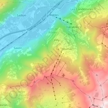
Name: Riddes topographic map, elevation, terrain.
Location: Riddes, Martigny, Wallis, Switzerland (46.09687 7.19640 46.18371 7.28057)
Average elevation: 4,626 ft
Minimum elevation: 1,519 ft
Maximum elevation: 9,820 ft
Thank you for supporting this site ❤️
Make a donation
Make a donation
Gear up for your next adventure:
As an Amazon Associate, this site earns from qualifying purchases at no extra cost to you.
Other topographic maps
Click on a map to view its topography, its elevation and its terrain.
Col de la Forclaz
Switzerland > Wallis > Martigny > Trient > Col de la Forclaz
Average elevation: 5,371 ft