Geolocate

Hinton topographic map

Click on the map to display elevation.

About this map

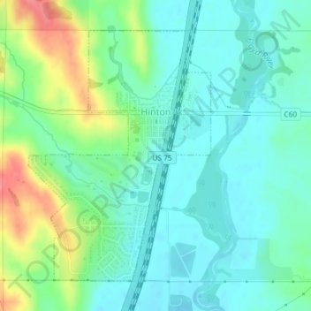
Name: Hinton topographic map, elevation, terrain.

Location: Hinton, Plymouth County, Iowa, 51204, United States (42.61197 -96.30898 42.63378 -96.28744)

Average elevation: 1,188 ft

Minimum elevation: 1,119 ft

Maximum elevation: 1,362 ft

Plymouth County trails, hiking, mountain biking, running and outdoor activities

Gear up for your next adventure:

🔥Plasma Lighters - Windproof lighters that work in any weather condition
🌧️Backpack Rain Cover - Keep gear dry in wet weather
🧷Carabiner Set - Durable clips for gear attachment
🎒Trail Energy Bars - High‑calorie bars for hiking energy
🛡️Insect Repellent - Protection against bugs during outdoor activities

As an Amazon Associate, this site earns from qualifying purchases at no extra cost to you.