
Drakensberg topographic map
Interactive map
Click on the map to display elevation.
About this map
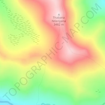
Name: Drakensberg topographic map, elevation, terrain.
Location: Drakensberg, Mokhotlong District, Lesotho (-29.47804 29.26727 -29.47794 29.26737)
Average elevation: 10,781 ft
Minimum elevation: 10,079 ft
Maximum elevation: 11,411 ft
Other topographic maps
Click on a map to view its topography, its elevation and its terrain.
Mok'hoek'hoe Ha Motlalepula
Mok'hoek'hoe Ha Motlalepula, Mokhotlong District, Lesotho
Average elevation: 8,711 ft
Thabana Ntlenyana
Thabana Ntlenyana, Mokhotlong District, Lesotho
Average elevation: 10,869 ft