Geolocate

Kano topographic map

Click on the map to display elevation.

About this map

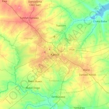
Name: Kano topographic map, elevation, terrain.

Location: Kano, Yakasai, Kano Municipal, Kano State, 700271, Nigeria (11.83187 8.37037 12.15187 8.69037)

Average elevation: 1,526 ft

Minimum elevation: 1,365 ft

Maximum elevation: 1,742 ft

Other topographic maps

Click on a map to view its topography, its elevation and its terrain.

Kan Karofi

Nigeria > Kano State > Kano Municipal

Average elevation: 1,581 ft

Sharada

Nigeria > Kano State > Kano Municipal

Average elevation: 1,575 ft

Gear up for your next adventure:

🧤Hiking Gloves - Protective gloves for rugged trails
🩳Quick‑Dry Hiking Shorts - Comfortable and quick‑dry shorts for summer hiking
🎒Outdoor Daypacks - Lightweight backpacks designed for carrying maps and essential gear
❄️Traction Cleats - Prevent slips on icy trails during winter hikes
🌄Hiking Binoculars - Compact binoculars for scenic views and trail spotting

As an Amazon Associate, this site earns from qualifying purchases at no extra cost to you.