
Frümsen topographic map
Interactive map
Click on the map to display elevation.
About this map
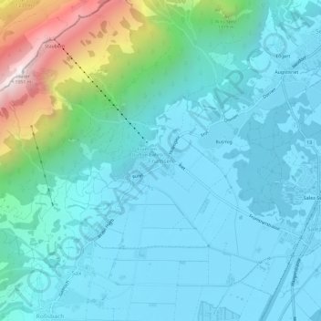
Name: Frümsen topographic map, elevation, terrain.
Average elevation: 2,267 ft
Minimum elevation: 1,424 ft
Maximum elevation: 6,332 ft
Other topographic maps
Click on a map to view its topography, its elevation and its terrain.
Gams
Schweiz > Sankt Gallen > Wahlkreis Werdenberg
Gams, Wahlkreis Werdenberg, Sankt Gallen, 9473, Schweiz
Average elevation: 2,589 ft
Buchs (SG)
Schweiz > Sankt Gallen > Wahlkreis Werdenberg > Buchs (SG)
Buchs (SG), Wahlkreis Werdenberg, Sankt Gallen, Schweiz
Average elevation: 1,890 ft
Grabs
Schweiz > Sankt Gallen > Wahlkreis Werdenberg > Grabs
Grabs, Wahlkreis Werdenberg, Sankt Gallen, 9472, Schweiz
Average elevation: 3,005 ft