
Thank you for supporting this site ❤️
Make a donation
Make a donation
Gear up for your next adventure:
As an Amazon Associate, this site earns from qualifying purchases at no extra cost to you.
Wattens topographic map
Click on the map to display elevation.
Thank you for supporting this site ❤️
Make a donation
Make a donation
Gear up for your next adventure:
As an Amazon Associate, this site earns from qualifying purchases at no extra cost to you.
About this map
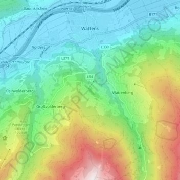
Name: Wattens topographic map, elevation, terrain.
Location: Wattens, Bezirk Innsbruck-Land, Tyrol, 6112, Austria (47.24255 11.57772 47.30307 11.61860)
Average elevation: 3,412 ft
Minimum elevation: 1,785 ft
Maximum elevation: 7,119 ft
Thank you for supporting this site ❤️
Make a donation
Make a donation
Gear up for your next adventure:
As an Amazon Associate, this site earns from qualifying purchases at no extra cost to you.