Geolocate

Manilva topographic map

Click on the map to display elevation.

About this map

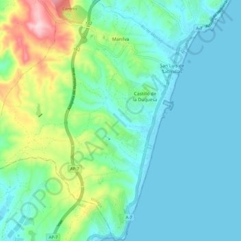
Name: Manilva topographic map, elevation, terrain.

Location: Manilva, Costa del Sol Occidental, Malaga, Andalusia, Spain (36.31035 -5.32008 36.38959 -5.22117)

Average elevation: 240 ft

Minimum elevation: 0 ft

Maximum elevation: 1,119 ft

Gear up for your next adventure:

🗻Climbing Gear Basics - Essential gear for beginner climbers
☀️Outdoor Sunscreen - High protection sunscreen for outdoor activities
🛌Ultralight Sleeping Bags - Compact down bags for cold nights in the wilderness
🌐World Map Poster - Decorative world maps with topographic info
🌡️Portable Weather Meter - Track weather conditions on the trail

As an Amazon Associate, this site earns from qualifying purchases at no extra cost to you.