
Thank you for supporting this site ❤️
Make a donation
Make a donation
Gear up for your next adventure:
As an Amazon Associate, this site earns from qualifying purchases at no extra cost to you.
Etxarri-Aranatz topographic map
Click on the map to display elevation.
Thank you for supporting this site ❤️
Make a donation
Make a donation
Gear up for your next adventure:
As an Amazon Associate, this site earns from qualifying purchases at no extra cost to you.
About this map
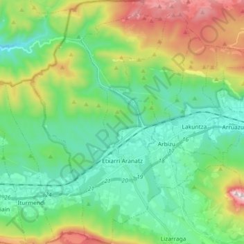
Name: Etxarri-Aranatz topographic map, elevation, terrain.
Location: Etxarri-Aranatz, Sakana, Navarre, 31820, Spain (42.87185 -2.11763 42.97643 -2.03950)
Average elevation: 2,280 ft
Minimum elevation: 1,322 ft
Maximum elevation: 4,646 ft
Thank you for supporting this site ❤️
Make a donation
Make a donation
Gear up for your next adventure:
As an Amazon Associate, this site earns from qualifying purchases at no extra cost to you.