
Kettwig topographic map
Interactive map
Click on the map to display elevation.
About this map
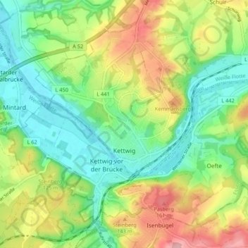
Name: Kettwig topographic map, elevation, terrain.
Average elevation: 308 ft
Minimum elevation: 118 ft
Maximum elevation: 617 ft
Other topographic maps
Click on a map to view its topography, its elevation and its terrain.
Karnap
Duitsland > Noordrijn-Westfalen > Essen > Siedlung Mathias-Stinnes
Karnap, Stadtbezirk V, Siedlung Mathias-Stinnes, Essen, Regierungsbezirk Düsseldorf, Noordrijn-Westfalen, Duitsland
Average elevation: 115 ft