
Volkmannsgrün topographic map
Interactive map
Click on the map to display elevation.
About this map
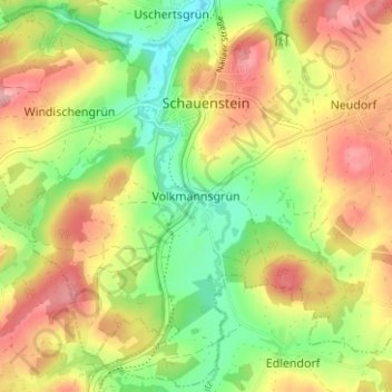
Name: Volkmannsgrün topographic map, elevation, terrain.
Average elevation: 1,900 ft
Minimum elevation: 1,693 ft
Maximum elevation: 2,110 ft
Other topographic maps
Click on a map to view its topography, its elevation and its terrain.
Kleinschmiedenhammer
Deutschland > Bayern > Landkreis Hof > Schauenstein > Uschertsgrün > Kleinschmiedenhammer
Kleinschmiedenhammer, Uschertsgrün, Schauenstein, Landkreis Hof, Bayern, 95197, Deutschland
Average elevation: 1,883 ft