
New Belgrade topographic map
Interactive map
Click on the map to display elevation.
About this map
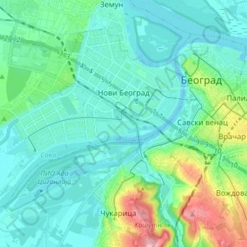
Name: New Belgrade topographic map, elevation, terrain.
Average elevation: 318 ft
Minimum elevation: 217 ft
Maximum elevation: 728 ft
Other topographic maps
Click on a map to view its topography, its elevation and its terrain.
Vracar
Serbia > Central Serbia > City of Belgrade > Belgrade
Vracar, Vracar Urban Municipality, Belgrade, City of Belgrade, Central Serbia, 11000, Serbia
Average elevation: 410 ft
Zemun
Serbia > Central Serbia > City of Belgrade > Belgrade
Zemun, Belgrade, City of Belgrade, Central Serbia, 11000, Serbia
Average elevation: 262 ft
Mirijevo
Serbia > Central Serbia > City of Belgrade > Belgrade
Mirijevo, Zvezdara, Zvezdara Urban Municipality, Belgrade, City of Belgrade, Central Serbia, 11050, Serbia
Average elevation: 614 ft