
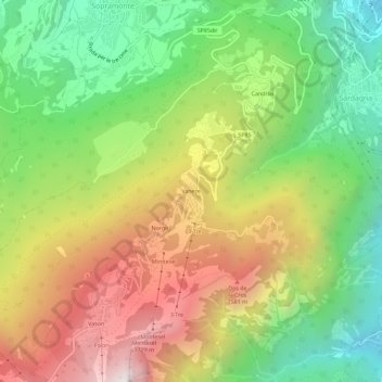
Vaneze topographic map
Interactive map
Click on the map to display elevation.
About this map
Name: Vaneze topographic map, elevation, terrain.
Average elevation: 3,327 ft
Minimum elevation: 1,007 ft
Maximum elevation: 6,276 ft
Other topographic maps
Click on a map to view its topography, its elevation and its terrain.
Vason
Italien > Trentino-Südtirol > Autonome Provinz Trient > Trient
Vason, Trient, Territorio Val d'Adige, Autonome Provinz Trient, Trentino-Südtirol, Italien
Average elevation: 4,409 ft
Candriai
Italien > Trentino-Südtirol > Autonome Provinz Trient > Trient > Sardagna
Candriai, Sardagna, Trient, Territorio Val d'Adige, Autonome Provinz Trient, Trentino-Südtirol, 38122, Italien
Average elevation: 2,441 ft
Sopramonte
Italien > Trentino-Südtirol > Autonome Provinz Trient > Trient
Sopramonte, Trient, Territorio Val d'Adige, Autonome Provinz Trient, Trentino-Südtirol, Italien
Average elevation: 2,356 ft
Trient
Italien > Trentino-Südtirol > Autonome Provinz Trient > Trient
Trient, Territorio Val d'Adige, Autonome Provinz Trient, Trentino-Südtirol, 38122, Italien
Average elevation: 3,182 ft