
Gangani topographic map
Interactive map
Click on the map to display elevation.
About this map
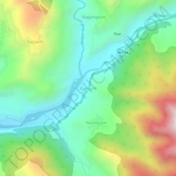
Name: Gangani topographic map, elevation, terrain.
Location: Gangani, Rajgarhi, Uttarkashi district, Uttarakhand, India (30.80901 78.23287 30.84901 78.27287)
Average elevation: 5,089 ft
Minimum elevation: 3,950 ft
Maximum elevation: 7,323 ft
Other topographic maps
Click on a map to view its topography, its elevation and its terrain.
Yamunotri
India > Uttarakhand > Rajgarhi
Yamunotri, Rajgarhi, Uttarkashi District, Uttarakhand, India
Average elevation: 12,113 ft
Barkot
India > Uttarakhand > Rajgarhi
Barkot, Rajgarhi, Uttarkashi district, Uttarakhand, India
Average elevation: 5,341 ft