
Hestern topographic map
Interactive map
Click on the map to display elevation.
About this map
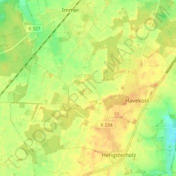
Name: Hestern topographic map, elevation, terrain.
Average elevation: 121 ft
Minimum elevation: 62 ft
Maximum elevation: 154 ft
Other topographic maps
Click on a map to view its topography, its elevation and its terrain.
Schiffstede
Deutschland > Niedersachsen > Landkreis Oldenburg > Ganderkesee
Schiffstede, Ganderkesee, Landkreis Oldenburg, Niedersachsen, 27777, Deutschland
Average elevation: 20 ft
Schönemoor
Deutschland > Niedersachsen > Landkreis Oldenburg > Ganderkesee
Schönemoor, Ganderkesee, Landkreis Oldenburg, Niedersachsen, 27753, Deutschland
Average elevation: 13 ft