
Rhens topographic map
Interactive map
Click on the map to display elevation.
About this map
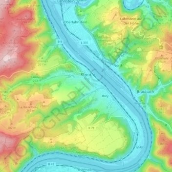
Name: Rhens topographic map, elevation, terrain.
Average elevation: 594 ft
Minimum elevation: 203 ft
Maximum elevation: 1,306 ft
Other topographic maps
Click on a map to view its topography, its elevation and its terrain.
Gering
Germany > Rhineland-Palatinate > Landkreis Mayen-Koblenz
Gering, Maifeld, Landkreis Mayen-Koblenz, Rhineland-Palatinate, Germany
Average elevation: 1,027 ft
Polch
Germany > Rhineland-Palatinate > Landkreis Mayen-Koblenz
Polch, Maifeld, Landkreis Mayen-Koblenz, Rhineland-Palatinate, 56751, Germany
Average elevation: 771 ft
Mendig
Germany > Rhineland-Palatinate > Landkreis Mayen-Koblenz
Mendig, Landkreis Mayen-Koblenz, Rhineland-Palatinate, 56743, Germany
Average elevation: 869 ft