
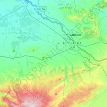
Aghbal topographic map
Interactive map
Click on the map to display elevation.
About this map
Name: Aghbal topographic map, elevation, terrain.
Average elevation: 1,332 ft
Minimum elevation: 151 ft
Maximum elevation: 4,944 ft
Other topographic maps
Click on a map to view its topography, its elevation and its terrain.
Ajdir
Maroc > Cercle d'Ahfir > Fezouane
Ajdir, Fezouane, caïdat d'Aghbal, Cercle d'Ahfir, Province de Berkane, Oriental, Maroc
Average elevation: 2,037 ft
Rehamna
Maroc > Cercle d'Ahfir > Aghbal
Rehamna, Aghbal, caïdat d'Aghbal, Cercle d'Ahfir, Province de Berkane, Oriental, 60330, Maroc
Average elevation: 1,122 ft
Moulouya
Maroc > Cercle d'Ahfir > Madagh
Moulouya, Madagh, caïdat de Madagh, Cercle d'Ahfir, Province de Berkane, Oriental, Maroc
Average elevation: 121 ft