
Make a donation
Gear up for your next adventure:
As an Amazon Associate, this site earns from qualifying purchases at no extra cost to you.
Constitutional Province of Callao topographic map
Click on the map to display elevation.
Make a donation
Gear up for your next adventure:
As an Amazon Associate, this site earns from qualifying purchases at no extra cost to you.
About this map
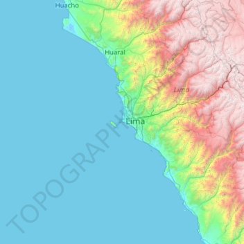
Name: Constitutional Province of Callao topographic map, elevation, terrain.
Location: Constitutional Province of Callao, Peru (-13.06667 -78.15000 -11.06667 -76.15000)
Average elevation: 3,310 ft
Minimum elevation: -10 ft
Maximum elevation: 17,677 ft
Make a donation
Gear up for your next adventure:
As an Amazon Associate, this site earns from qualifying purchases at no extra cost to you.
Other topographic maps
Click on a map to view its topography, its elevation and its terrain.
Make a donation
Gear up for your next adventure:
As an Amazon Associate, this site earns from qualifying purchases at no extra cost to you.
Ancash
The park territory is very uneven. It has snowy summits, which altitudes vary between 5000 and 6768 MSL. It also has gullies, that are deeply encased because of the fluvioglacial erosion, and a great number of lagoons. Inside the borders of the park, there are 663 glaciers that are distributed throughout 180…
Average elevation: 6,959 ft
Make a donation
Gear up for your next adventure:
As an Amazon Associate, this site earns from qualifying purchases at no extra cost to you.
Arequipa
This department has a rough topography, which is characterised by heavy layers of volcanic lava covering large areas of its inter-Andean sector. It has deep canyons such as the ones formed by the Ocoña and Majes rivers. Plateaus range in height from medium, such as La Joya, and high-altitude ones such the…
Average elevation: 8,527 ft
Make a donation
Gear up for your next adventure:
As an Amazon Associate, this site earns from qualifying purchases at no extra cost to you.