Geolocate

Cross City topographic map

Click on the map to display elevation.

About this map
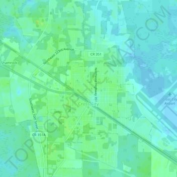
Name: Cross City topographic map, elevation, terrain.

Location: Cross City, Dixie County, Florida, 32628, United States (29.61855 -83.13918 29.65675 -83.10902)

Average elevation: 49 ft

Minimum elevation: 33 ft

Maximum elevation: 69 ft

Dixie County trails, hiking, mountain biking, running and outdoor activities

Other topographic maps

Click on a map to view its topography, its elevation and its terrain.
Old Town

United States > Florida > Dixie County

Average elevation: 23 ft

Jena

United States > Florida > Dixie County

Average elevation: 20 ft

Palm Island

United States > Florida > Dixie County

Average elevation: 13 ft

Gear up for your next adventure:

☀️Outdoor Sunscreen - High protection sunscreen for outdoor activities
🔥Plasma Lighters - Windproof lighters that work in any weather condition
🖼️Topo Map Wall Art - Decorative topographic prints of famous peaks and regions
🥇GPS Hiking Watch - Multi‑sport GPS watch with navigation and trail tracking
🪶Multi‑Purpose Knife - Useful blade for camp and trail

As an Amazon Associate, this site earns from qualifying purchases at no extra cost to you.