
Δημοτική Ενότητα Διστόμου topographic map
Interactive map
Click on the map to display elevation.
About this map
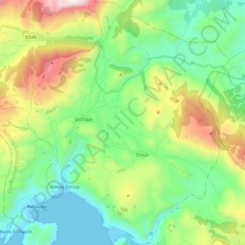
Name: Δημοτική Ενότητα Διστόμου topographic map, elevation, terrain.
Average elevation: 1,873 ft
Minimum elevation: 0 ft
Maximum elevation: 6,201 ft
Other topographic maps
Click on a map to view its topography, its elevation and its terrain.
Σκοπιά
Greece > Thessaly and Central Greece > Regional Unit of Boeotia > Municipal Unit of Akrefnia
Σκοπιά, Municipal Unit of Akrefnia, Municipality of Orchomenos, Regional Unit of Boeotia, Central Greece, Thessaly and Central Greece, Greece
Average elevation: 673 ft
Livadia
Greece > Thessaly and Central Greece > Regional Unit of Boeotia > Levadia Municipal Unit
Livadia, Levadia Municipal Unit, Municipality of Livadia, Regional Unit of Boeotia, Central Greece, Thessaly and Central Greece, 321 00, Greece
Average elevation: 1,027 ft
Tanagra
Greece > Thessaly and Central Greece > Regional Unit of Boeotia > Δημοτική Ενότητα Τανάγρας > Tanagra
Tanagra, Δημοτική Ενότητα Τανάγρας, Municipality of Tanagra, Regional Unit of Boeotia, Central Greece, Thessaly and Central Greece, 32009, Greece
Average elevation: 758 ft