
Dolphin Island topographic map
Interactive map
Click on the map to display elevation.
About this map
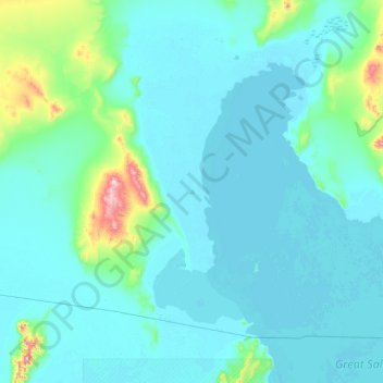
Name: Dolphin Island topographic map, elevation, terrain.
Location: Dolphin Island, Box Elder County, Utah, USA (41.14520 -113.32193 41.78520 -112.68193)
Average elevation: 4,423 ft
Minimum elevation: 4,193 ft
Maximum elevation: 6,909 ft
Other topographic maps
Click on a map to view its topography, its elevation and its terrain.
Logan River
Logan River, Logan, Cache County, Utah, 84321, USA
Average elevation: 4,692 ft
La Sal Mountains Viewpoint
La Sal Mountains Viewpoint, Arches Entrance Road, Grand County, Utah, 84532-2134, USA
Average elevation: 4,419 ft
Timpanogos Glacier
USA > Utah > Aspen Grove
Timpanogos Glacier, Mount Timpanogos Trail #052, Aspen Grove, Utah County, Utah, USA
Average elevation: 10,328 ft
Kanab Creek
Kanab Creek, Kanab, Kane County, Utah, 86074, USA
Average elevation: 4,921 ft
Canyonlands National Park - Maze District
Canyonlands National Park - Maze District, White Rim Road, San Juan County, Utah, USA
Average elevation: 5,072 ft
Castle Cliff
USA > Utah > St. George
Castle Cliff, Old US Highway 91, St. George, Washington County, Utah, USA
Average elevation: 3,950 ft