
Māngere-Ōtāhuhu topographic map
Interactive map
Click on the map to display elevation.
About this map
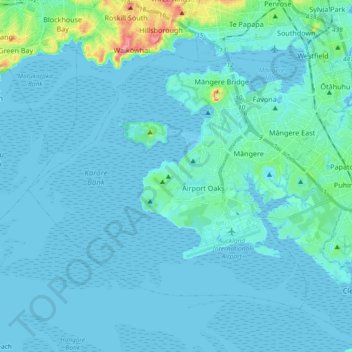
Name: Māngere-Ōtāhuhu topographic map, elevation, terrain.
Location: Māngere-Ōtāhuhu, Auckland, New Zealand (-37.03952 174.68320 -36.92779 174.86841)
Average elevation: 33 ft
Minimum elevation: -7 ft
Maximum elevation: 361 ft
Other topographic maps
Click on a map to view its topography, its elevation and its terrain.
Otahuhu
New Zealand > Auckland > Māngere-Ōtāhuhu
Otahuhu, Māngere-Ōtāhuhu, Auckland, New Zealand
Average elevation: 39 ft