
La Grée topographic map
Interactive map
Click on the map to display elevation.
About this map
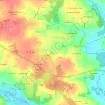
Name: La Grée topographic map, elevation, terrain.
Average elevation: 213 ft
Minimum elevation: 82 ft
Maximum elevation: 325 ft
Other topographic maps
Click on a map to view its topography, its elevation and its terrain.
Beau Soleil
France > Bretagne > Morbihan > La Croix-Helléan
Beau Soleil, La Croix-Helléan, Pontivy, Morbihan, Bretagne, France métropolitaine, 56120, France
Average elevation: 220 ft
La Ville Raffray
France > Bretagne > Morbihan > La Croix-Helléan
La Ville Raffray, La Croix-Helléan, Pontivy, Morbihan, Bretagne, France métropolitaine, 56120, France
Average elevation: 217 ft