
Make a donation
Gear up for your next adventure:
As an Amazon Associate, this site earns from qualifying purchases at no extra cost to you.
Var topographic map
Click on the map to display elevation.
Make a donation
Gear up for your next adventure:
As an Amazon Associate, this site earns from qualifying purchases at no extra cost to you.
Var
The plateau of Canjuers (French: Plan de Canjuers) in the northeast of Var gradually rises from 500 to 1,000 metres. In the south and west there are several plateaus, such as the plateau of Siou Blanc to the north of Toulon, which rise from 400 to 700 metres in altitude.
Make a donation
Gear up for your next adventure:
As an Amazon Associate, this site earns from qualifying purchases at no extra cost to you.
About this map
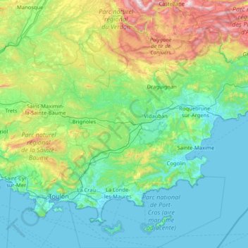
Name: Var topographic map, elevation, terrain.
Location: Var, Provence-Alpes-Côte d'Azur, Metropolitan France, France (42.98201 5.65603 43.80874 6.93324)
Average elevation: 1,063 ft
Minimum elevation: -7 ft
Maximum elevation: 6,188 ft
Make a donation
Gear up for your next adventure:
As an Amazon Associate, this site earns from qualifying purchases at no extra cost to you.
Other topographic maps
Click on a map to view its topography, its elevation and its terrain.
Aix-en-Provence
France > Provence-Alpes-Côte d'Azur > Bouches-du-Rhône > Aix-en-Provence
Average elevation: 915 ft
L'Isle-sur-la-Sorgue
France > Provence-Alpes-Côte d'Azur > Vaucluse > L'Isle-sur-la-Sorgue > L'Isle-sur-la-Sorgue
Average elevation: 262 ft
Make a donation
Gear up for your next adventure:
As an Amazon Associate, this site earns from qualifying purchases at no extra cost to you.
Pic Gaspard
France > Provence-Alpes-Côte d'Azur > Hautes-Alpes > Villar-d'Arêne
Average elevation: 10,318 ft
Col du Lautaret
France > Provence-Alpes-Côte d'Azur > Hautes-Alpes > Le Monêtier-les-Bains
From the west, the climb starts at Les Clapier, near Le Bourg-d'Oisans, from where the climb is 34.2 km (21.3 mi) long, gaining 1,312 m (4,304 ft) in altitude, at an average gradient of 3.8%, with the steepest section being at 7.5% in the first kilometre.
Average elevation: 7,418 ft
Colombis
France > Provence-Alpes-Côte d'Azur > Vaucluse > Châteauneuf-du-Pape > La Croze
Average elevation: 190 ft
Make a donation
Gear up for your next adventure:
As an Amazon Associate, this site earns from qualifying purchases at no extra cost to you.
Le Canadel
France > Provence-Alpes-Côte d'Azur > Var > Rayol-Canadel-sur-Mer
Average elevation: 443 ft
Mont Agel
France > Provence-Alpes-Côte d'Azur > Maritime Alps > Peille
Mont Agel is a mountain in the Maritime Alps on the border between France and Monaco. The summit of this mount, at 1,148 metres (3,766 ft) above sea level, is on the French side, but the highest point of Monaco, lying on a pathway named Chemin des Révoires, is on its slopes, at an altitude of 161 metres (528…
Average elevation: 2,592 ft
Les Meyries
France > Provence-Alpes-Côte d'Azur > Hautes-Alpes > Freissinières
Average elevation: 4,846 ft
Make a donation
Gear up for your next adventure:
As an Amazon Associate, this site earns from qualifying purchases at no extra cost to you.
Barre des Écrins
France > Provence-Alpes-Côte d'Azur > Hautes-Alpes > Vallouise-Pelvoux
The Barre des Écrins (French pronunciation: [baʁ dez‿ekʁɛ̃]) is a mountain in the French Alps with a peak elevation of 4,102 metres (13,458 ft). It is the highest peak of the Massif des Écrins and the Dauphiné Alps and the most southerly alpine peak in Europe that is higher than 4,000 metres. It is…
Average elevation: 10,571 ft
Mont Ventoux
France > Provence-Alpes-Côte d'Azur > Vaucluse > Saint-Léger-du-Ventoux
There are two small ski stations on the mountain: "Mont Serein" on the north side, and "Chalet Reynard" on the south. High winds and the modest elevation tend to limit the ski season. Weather conditions are such that the northern slope is often icy, leading to a saying among people of the surrounding region…
Average elevation: 5,108 ft
Make a donation
Gear up for your next adventure:
As an Amazon Associate, this site earns from qualifying purchases at no extra cost to you.
Lac du Sautet
France > Provence-Alpes-Côte d'Azur > Hautes-Alpes > Aspres-lès-Corps
Average elevation: 3,461 ft
Le Camp du Castellet
France > Provence-Alpes-Côte d'Azur > Var > Le Castellet
Average elevation: 1,217 ft
Cime de Campbel
France > Provence-Alpes-Côte d'Azur > Maritime Alps > Fontan
Average elevation: 3,163 ft
Orcières-Merlette
France > Provence-Alpes-Côte d'Azur > Hautes-Alpes > Orcières
Average elevation: 6,148 ft
Make a donation
Gear up for your next adventure:
As an Amazon Associate, this site earns from qualifying purchases at no extra cost to you.
Mont Saint-Cyr
France > Provence-Alpes-Côte d'Azur > Bouches-du-Rhône > Marseille
Average elevation: 1,253 ft
Le Garlaban
France > Provence-Alpes-Côte d'Azur > Bouches-du-Rhône > Aubagne
Average elevation: 1,503 ft
Chavailles
France > Provence-Alpes-Côte d'Azur > Alpes-de-Haute-Provence > Prads-Haute-Bléone
Average elevation: 4,892 ft
Puget-Théniers
France > Provence-Alpes-Côte d'Azur > Maritime Alps > Puget-Théniers
Average elevation: 2,257 ft
Make a donation
Gear up for your next adventure:
As an Amazon Associate, this site earns from qualifying purchases at no extra cost to you.
Revest
France > Provence-Alpes-Côte d'Azur > Alpes-de-Haute-Provence > Malijai
Average elevation: 1,719 ft
La Redoute des 3 Communes
France > Provence-Alpes-Côte d'Azur > Maritime Alps > Moulinet
Average elevation: 5,705 ft
Le Rhône - Bras Mort de la Barthelasse
France > Provence-Alpes-Côte d'Azur > Vaucluse > Avignon
Average elevation: 79 ft
Make a donation
Gear up for your next adventure:
As an Amazon Associate, this site earns from qualifying purchases at no extra cost to you.
Saint Antoine
France > Provence-Alpes-Côte d'Azur > Maritime Alps > Sospel
Average elevation: 1,883 ft
Matheron
France > Provence-Alpes-Côte d'Azur > Bouches-du-Rhône > Pélissanne
Average elevation: 390 ft
Ailefroide
France > Provence-Alpes-Côte d'Azur > Hautes-Alpes > Vallouise-Pelvoux
Average elevation: 6,690 ft
Make a donation
Gear up for your next adventure:
As an Amazon Associate, this site earns from qualifying purchases at no extra cost to you.
Pic Gaspard
France > Provence-Alpes-Côte d'Azur > Hautes-Alpes > Villar-d'Arêne
Average elevation: 10,318 ft
forêt de Sainte barbe
France > Provence-Alpes-Côte d'Azur > Var > Draguignan
Average elevation: 771 ft
Make a donation
Gear up for your next adventure:
As an Amazon Associate, this site earns from qualifying purchases at no extra cost to you.
Les Gondoins
France > Provence-Alpes-Côte d'Azur > Hautes-Alpes > Les Borels
Average elevation: 5,699 ft
Bassin du Vallon Dol
France > Provence-Alpes-Côte d'Azur > Bouches-du-Rhône > Marseille
Average elevation: 791 ft
Pramouton
France > Provence-Alpes-Côte d'Azur > Hautes-Alpes > Saint-André-d'Embrun
Average elevation: 6,841 ft
Mont d'Or
France > Provence-Alpes-Côte d'Azur > Alpes-de-Haute-Provence > Manosque
Average elevation: 1,293 ft
Make a donation
Gear up for your next adventure:
As an Amazon Associate, this site earns from qualifying purchases at no extra cost to you.
La Croix
France > Provence-Alpes-Côte d'Azur > Alpes-de-Haute-Provence > Jausiers
Average elevation: 6,982 ft
Col de Turini
France > Provence-Alpes-Côte d'Azur > Maritime Alps > Moulinet
Average elevation: 5,082 ft
Make a donation
Gear up for your next adventure:
As an Amazon Associate, this site earns from qualifying purchases at no extra cost to you.
Ruines du Barrage de Malpasset
France > Provence-Alpes-Côte d'Azur > Var > Fréjus
Average elevation: 387 ft
Le Caravon
France > Provence-Alpes-Côte d'Azur > Alpes-de-Haute-Provence > Oppedette
Average elevation: 1,814 ft
Molanès
France > Provence-Alpes-Côte d'Azur > Alpes-de-Haute-Provence > Uvernet-Fours
Average elevation: 5,138 ft
Make a donation
Gear up for your next adventure:
As an Amazon Associate, this site earns from qualifying purchases at no extra cost to you.
Le Pied du Col
France > Provence-Alpes-Côte d'Azur > Hautes-Alpes > Villar-d'Arêne
Average elevation: 6,893 ft
Station de ski de Céüze
France > Provence-Alpes-Côte d'Azur > Hautes-Alpes > Manteyer
Average elevation: 5,184 ft
Val d'Esquieres
France > Provence-Alpes-Côte d'Azur > Var > Roquebrune-sur-Argens
Average elevation: 269 ft
Make a donation
Gear up for your next adventure:
As an Amazon Associate, this site earns from qualifying purchases at no extra cost to you.
Source du Mirail
France > Provence-Alpes-Côte d'Azur > Vaucluse > Peypin-d'Aigues
Average elevation: 1,617 ft
Plage de Bonporteau
France > Provence-Alpes-Côte d'Azur > Var > Cavalaire-sur-Mer
Average elevation: 135 ft
Barrage de Bimont
France > Provence-Alpes-Côte d'Azur > Bouches-du-Rhône > Saint-Marc-Jaumegarde
Average elevation: 1,161 ft
Make a donation
Gear up for your next adventure:
As an Amazon Associate, this site earns from qualifying purchases at no extra cost to you.
Gorgia
France > Provence-Alpes-Côte d'Azur > Maritime Alps > Saint-Étienne-de-Tinée
Average elevation: 4,964 ft
Saint-Disdier
France > Provence-Alpes-Côte d'Azur > Hautes-Alpes > Le Dévoluy
Average elevation: 4,357 ft
Auron
France > Provence-Alpes-Côte d'Azur > Maritime Alps > Saint-Étienne-de-Tinée
Auron is a ski resort in the department of Alpes-Maritimes and the region of Provence-Alpes-Côte d'Azur in France. The resort has 135 kilometres (84 mi) of ski runs, at an elevation of between 1,600 and 2,450 m (5,250 and 8,040 ft) in the French Alps. It is located above the Tinée Valley near the town of…
Average elevation: 5,427 ft
Make a donation
Gear up for your next adventure:
As an Amazon Associate, this site earns from qualifying purchases at no extra cost to you.
Villeneuve
France > Provence-Alpes-Côte d'Azur > Hautes-Alpes > La Salle-les-Alpes
Average elevation: 5,554 ft
Ctete de Praroussin
France > Provence-Alpes-Côte d'Azur > Hautes-Alpes > Abriès-Ristolas
Average elevation: 7,264 ft
Saint-Michel
France > Provence-Alpes-Côte d'Azur > Alpes-de-Haute-Provence > Moustiers-Sainte-Marie
Average elevation: 2,398 ft
Les Alpes
France > Provence-Alpes-Côte d'Azur > Hautes-Alpes > Saint-Marcelin
Average elevation: 3,520 ft
Make a donation
Gear up for your next adventure:
As an Amazon Associate, this site earns from qualifying purchases at no extra cost to you.
Le Baguier
France > Provence-Alpes-Côte d'Azur > Bouches-du-Rhône > La Ciotat
Average elevation: 417 ft
La Cride
France > Provence-Alpes-Côte d'Azur > Bouches-du-Rhône > Le Puy-Sainte-Réparade
Average elevation: 997 ft
Make a donation
Gear up for your next adventure:
As an Amazon Associate, this site earns from qualifying purchases at no extra cost to you.
Make a donation
Gear up for your next adventure:
As an Amazon Associate, this site earns from qualifying purchases at no extra cost to you.
La Rousse
France > Provence-Alpes-Côte d'Azur > Hautes-Alpes > Saint-Véran
Average elevation: 8,022 ft
Sainte-Claire
France > Provence-Alpes-Côte d'Azur > Maritime Alps > Guillaumes
Average elevation: 3,488 ft
La Madone
France > Provence-Alpes-Côte d'Azur > Maritime Alps > Saint-Martin-Vésubie
Average elevation: 3,776 ft
Make a donation
Gear up for your next adventure:
As an Amazon Associate, this site earns from qualifying purchases at no extra cost to you.
Make a donation
Gear up for your next adventure:
As an Amazon Associate, this site earns from qualifying purchases at no extra cost to you.
Mont Agel
France > Provence-Alpes-Côte d'Azur > Maritime Alps > Peille
Mont Agel is a mountain on the border between France and Monaco. The summit of this mount, at 1,148 metres (3,766 ft) above sea level, is on the French side, but the highest point of Monaco, lying on a pathway named Chemin des Révoires, is on its slopes, at an altitude of 161 metres (528 feet).
Average elevation: 2,592 ft
La Foux d'Allos
France > Provence-Alpes-Côte d'Azur > Alpes-de-Haute-Provence > Allos
Average elevation: 6,870 ft
Avignon
France > Provence-Alpes-Côte d'Azur > Vaucluse > Avignon
Enclosed by the city walls, the Rocher des Doms is a limestone elevation of Urgonian type, 35 metres high (and therefore safe from flooding of the Rhone which it overlooks) and is the original core of the city. Several limestone massifs are present around the commune (the Massif des Angles,…
Average elevation: 190 ft
Make a donation
Gear up for your next adventure:
As an Amazon Associate, this site earns from qualifying purchases at no extra cost to you.
Ailefroide
France > Provence-Alpes-Côte d'Azur > Hautes-Alpes > Vallouise-Pelvoux
Average elevation: 6,690 ft
Make a donation
Gear up for your next adventure:
As an Amazon Associate, this site earns from qualifying purchases at no extra cost to you.
Briançon
France > Provence-Alpes-Côte d'Azur > Hautes-Alpes > Briançon > Briançon
Due to its elevation, Briançon features a warm-summer humid continental climate (Köppen : Dfb), bordering on an oceanic climate (Cfb) under the Köppen system. Summers are warm with cool nights, and winters are cold and snowy.
Average elevation: 5,364 ft
Le Petit Buëch
France > Provence-Alpes-Côte d'Azur > Hautes-Alpes > La Roche-des-Arnauds > Les Baux
Average elevation: 3,720 ft
Serre Chevalier
France > Provence-Alpes-Côte d'Azur > Hautes-Alpes > Puy-Saint-André
The maximum elevation for skiing is at Telesiege Yret at 2,800 m (9,190 ft) above sea level, and the minimum is 1,200 m (3,940 ft), a total vertical drop of 1,600 m (5,250 ft). One of the outstanding features of Serre Chevalier is the wooded nature of the slopes. The timber line is at 2,150 m (7,050 ft),…
Average elevation: 7,402 ft
Barcelonnette
France > Provence-Alpes-Côte d'Azur > Alpes-de-Haute-Provence > Barcelonnette > Barcelonnette
Barcelonnette is situated in the wide and fertile Ubaye Valley, of which it is the largest town. It lies at an elevation of 1132 m (3717 ft) on the right bank of the Ubaye River, and is surrounded by mountains which reach peaks of over 3000 m; the tallest of these is the Needle of Chambeyron at 3412 m.…
Average elevation: 4,902 ft
Make a donation
Gear up for your next adventure:
As an Amazon Associate, this site earns from qualifying purchases at no extra cost to you.
Le Plan
France > Provence-Alpes-Côte d'Azur > Var > Plan-d'Aups-Sainte-Baume
Average elevation: 2,362 ft
Sainte-Marie
France > Provence-Alpes-Côte d'Azur > Hautes-Alpes > Vars > Sainte-Marie
Average elevation: 6,585 ft
Make a donation
Gear up for your next adventure:
As an Amazon Associate, this site earns from qualifying purchases at no extra cost to you.
Beaumont du Ventoux
France > Provence-Alpes-Côte d'Azur > Vaucluse > Beaumont-du-Ventoux
Average elevation: 1,644 ft
Make a donation
Gear up for your next adventure:
As an Amazon Associate, this site earns from qualifying purchases at no extra cost to you.