
Make a donation
Gear up for your next adventure:
As an Amazon Associate, this site earns from qualifying purchases at no extra cost to you.
Porto Alegre topographic map
Click on the map to display elevation.
Make a donation
Gear up for your next adventure:
As an Amazon Associate, this site earns from qualifying purchases at no extra cost to you.
Porto Alegre
Porto Alegre has a long coastline on the Guaíba Lake, and its topography is punctuated by 40 hills. In the lake, a vast body of water, a maze of islands facing the city creates an archipelago where a unique ecosystem gives shelter to abundant wildlife. The city area concentrates 28% of the native flora of Rio Grande do Sul, with 9,288 species. Among these, there are many trees which are vestiges of the Atlantic Forest. Fauna are also diversified, especially in the islands and hills. The Portoalegrense environs include many parks, squares and wooded streets.
Make a donation
Gear up for your next adventure:
As an Amazon Associate, this site earns from qualifying purchases at no extra cost to you.
About this map
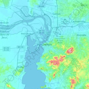
Name: Porto Alegre topographic map, elevation, terrain.
Average elevation: 89 ft
Minimum elevation: -3 ft
Maximum elevation: 1,010 ft
Make a donation
Gear up for your next adventure:
As an Amazon Associate, this site earns from qualifying purchases at no extra cost to you.
Other topographic maps
Click on a map to view its topography, its elevation and its terrain.
Passo da Areia
Brazil > Rio Grande do Sul > Metropolitan Region of Porto Alegre > Porto Alegre
Average elevation: 98 ft
Arquipélago
Brazil > Rio Grande do Sul > Metropolitan Region of Porto Alegre > Porto Alegre
Average elevation: 33 ft
Glória
Brazil > Rio Grande do Sul > Metropolitan Region of Porto Alegre > Porto Alegre
Average elevation: 384 ft
Boa Vista
Brazil > Rio Grande do Sul > Metropolitan Region of Porto Alegre > Porto Alegre
Average elevation: 154 ft
Make a donation
Gear up for your next adventure:
As an Amazon Associate, this site earns from qualifying purchases at no extra cost to you.