
Bihać topographic map
Click on the map to display elevation.
About this map
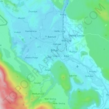
Name: Bihać topographic map, elevation, terrain.
Average elevation: 1,207 ft
Minimum elevation: 673 ft
Maximum elevation: 4,416 ft
Other topographic maps
Click on a map to view its topography, its elevation and its terrain.
Ripač
Bosnia and Herzegovina > Federation of Bosnia and Herzegovina > City of Bihać
Average elevation: 1,037 ft
Trubar
Bosnia and Herzegovina > Federation of Bosnia and Herzegovina > City of Bihać
Average elevation: 2,270 ft
Una
Bosnia and Herzegovina > Federation of Bosnia and Herzegovina > City of Bihać > Bihać
Average elevation: 837 ft
Una
Bosnia and Herzegovina > Federation of Bosnia and Herzegovina > City of Bihać > Bihać
Average elevation: 837 ft
Tukovi
Bosnia and Herzegovina > Federation of Bosnia and Herzegovina > City of Bihać
Average elevation: 2,726 ft