
Thank you for supporting this site ❤️
Make a donation
Make a donation
Gear up for your next adventure:
As an Amazon Associate, this site earns from qualifying purchases at no extra cost to you.
Ilfracombe topographic map
Click on the map to display elevation.
Thank you for supporting this site ❤️
Make a donation
Make a donation
Gear up for your next adventure:
As an Amazon Associate, this site earns from qualifying purchases at no extra cost to you.
About this map
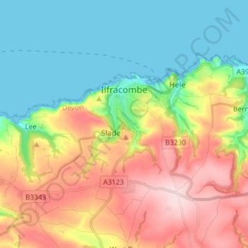
Name: Ilfracombe topographic map, elevation, terrain.
Location: Ilfracombe, North Devon, Devon, England, United Kingdom (51.17534 -4.19772 51.21887 -4.07668)
Average elevation: 341 ft
Minimum elevation: 0 ft
Maximum elevation: 866 ft
Thank you for supporting this site ❤️
Make a donation
Make a donation
Gear up for your next adventure:
As an Amazon Associate, this site earns from qualifying purchases at no extra cost to you.
Other topographic maps
Click on a map to view its topography, its elevation and its terrain.
St John's Chapel
United Kingdom > England > Devon > North Devon > Eastacombe
Average elevation: 256 ft