
Täschhorn topographic map
Interactive map
Click on the map to display elevation.
About this map
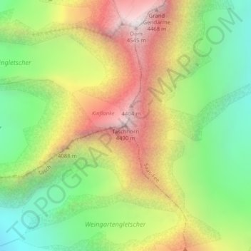
Name: Täschhorn topographic map, elevation, terrain.
Location: Täschhorn, Täsch, Visp, Vallese, 3929, Svizzera (46.08338 7.85714 46.08348 7.85724)
Average elevation: 12,215 ft
Minimum elevation: 10,033 ft
Maximum elevation: 14,888 ft
Other topographic maps
Click on a map to view its topography, its elevation and its terrain.