
Managua topographic map
Interactive map
Click on the map to display elevation.
About this map
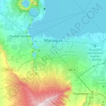
Name: Managua topographic map, elevation, terrain.
Location: Managua, 10000 (codigo maestro), Nicaragua (12.02118 -86.39185 12.22427 -86.12571)
Average elevation: 732 ft
Minimum elevation: 118 ft
Maximum elevation: 3,074 ft
Managua's city area extends about 544 square kilometers (210 square miles), essentially south from the south shore of Lake Managua. The lakeshore is at an altitude of 55 meters (180 feet) above sea level, and the city climbs as it gets towards the Sierras de Managua further south where it is over 700 meters (2,297 feet) above sea level.
Other topographic maps
Click on a map to view its topography, its elevation and its terrain.
Distrito III
Distrito III, Managua, Nicaragua
Average elevation: 1,010 ft
Distrito II
Distrito II, Managua, 12000, Nicaragua
Average elevation: 269 ft
Tipitapa (Municipio)
Tipitapa (Municipio), Managua, 15100, Nicaragua
Average elevation: 509 ft
San Rafael del Sur (Municipio)
Nicaragua > Managua > San Rafael del Sur (Municipio)
San Rafael del Sur (Municipio), Managua, 16700, Nicaragua
Average elevation: 404 ft
Mateare (Municipio)
Mateare (Municipio), Managua, 15500, Nicaragua
Average elevation: 394 ft