
Make a donation
Gear up for your next adventure:
As an Amazon Associate, this site earns from qualifying purchases at no extra cost to you.
Viseu topographic map
Click on the map to display elevation.
Make a donation
Gear up for your next adventure:
As an Amazon Associate, this site earns from qualifying purchases at no extra cost to you.
Viseu
The Municipality is characterized by an irregular surface with altitudes ranging between 400 and 700 metres (1,300 and 2,300 feet). With a rough terrain, it has numerous water courses. These are found in three basins: the Vouga, the Dão and the Paiva.
Make a donation
Gear up for your next adventure:
As an Amazon Associate, this site earns from qualifying purchases at no extra cost to you.
About this map
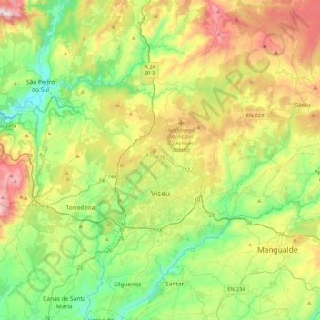
Name: Viseu topographic map, elevation, terrain.
Location: Viseu, Portugal (40.53573 -8.09159 40.84260 -7.75898)
Average elevation: 1,539 ft
Minimum elevation: 479 ft
Maximum elevation: 3,501 ft
Make a donation
Gear up for your next adventure:
As an Amazon Associate, this site earns from qualifying purchases at no extra cost to you.