
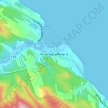
Rivière-au-Renard topographic map
Interactive map
Click on the map to display elevation.
About this map
Name: Rivière-au-Renard topographic map, elevation, terrain.
Average elevation: 144 ft
Minimum elevation: -10 ft
Maximum elevation: 846 ft
Other topographic maps
Click on a map to view its topography, its elevation and its terrain.
Fontenelle
Canada > Québec > La Côte-de-Gaspé > Gaspé
Fontenelle, Gaspé, La Côte-de-Gaspé, Gaspésie–Îles-de-la-Madeleine, Québec, G4X 6R1, Canada
Average elevation: 200 ft
L'Anse-au-Griffon-Nord
Canada > Québec > La Côte-de-Gaspé > Gaspé > L'Anse-au-Griffon
L'Anse-au-Griffon-Nord, L'Anse-au-Griffon, Gaspé, La Côte-de-Gaspé, Gaspésie–Îles-de-la-Madeleine, Québec, G4X 6A6, Canada
Average elevation: 138 ft
Lac Caribou
Canada > Québec > La Côte-de-Gaspé > Gaspé
Lac Caribou, Gaspé, La Côte-de-Gaspé, Gaspésie–Îles-de-la-Madeleine, Québec, Canada
Average elevation: 863 ft
Cap-aux-Os
Canada > Québec > La Côte-de-Gaspé > Gaspé
Cap-aux-Os, Gaspé, La Côte-de-Gaspé, Gaspésie–Îles-de-la-Madeleine, Québec, G4X 6L6, Canada
Average elevation: 223 ft