
Portimão topographic map
Interactive map
Click on the map to display elevation.
About this map
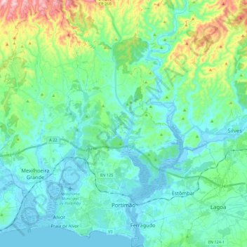
Name: Portimão topographic map, elevation, terrain.
Location: Portimão, Faro, Portugal (37.10842 -8.68466 37.27992 -8.48520)
Average elevation: 220 ft
Minimum elevation: -26 ft
Maximum elevation: 1,089 ft
The geographical distribution of the altitude and relief of the municipality of Portimão generically follow the three types of territory present in the Barlavento: the coastal region, the Barrocal (a region between the coastal region and the mountains) and the mountains up north. Each one with their own geological, morphological and pedagogical characteristics.
Other topographic maps
Click on a map to view its topography, its elevation and its terrain.
Praia do Beliche
Praia do Beliche, Sagres, Vila do Bispo, Faro, Portugal
Average elevation: 95 ft
Estorninhos
Estorninhos, Conceição e Cabanas de Tavira, Tavira, Faro, 8800-071, Portugal
Average elevation: 568 ft
Martim Longo
Martim Longo, Alcoutim, Faro, 8970-261, Portugal
Average elevation: 801 ft
São Bartolomeu de Messines
São Bartolomeu de Messines, Silves, Faro, Portugal
Average elevation: 558 ft
Caramujeira
Caramujeira, Lagoa, Lagoa e Carvoeiro, Lagoa, Faro, 8400-407, Portugal
Average elevation: 141 ft
Alcoutim
Portugal > Faro > Alcoutim e Pereiro > Alcoutim
Alcoutim, Alcoutim e Pereiro, Alcoutim, Faro, Portugal
Average elevation: 194 ft
Bensafrim
Portugal > Faro > Bensafrim e Barão de São João
Bensafrim, Bensafrim e Barão de São João, Lagos, Faro, 8600-069, Portugal
Average elevation: 230 ft
Moncarapacho
Portugal > Faro > Moncarapacho e Fuseta > Moncarapacho
Moncarapacho, Moncarapacho e Fuseta, Olhão, Faro, 8700-095, Portugal
Average elevation: 246 ft