
Longkamp topographic map
Interactive map
Click on the map to display elevation.
About this map
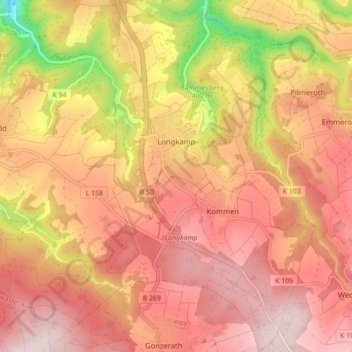
Name: Longkamp topographic map, elevation, terrain.
Average elevation: 1,398 ft
Minimum elevation: 449 ft
Maximum elevation: 1,913 ft
Longkamp ist eine Ortsgemeinde im Landkreis Bernkastel-Wittlich in Rheinland-Pfalz. Sie gehört der Verbandsgemeinde Bernkastel-Kues an und liegt am Rande des Hunsrücks auf den Mosel-Höhen.
Other topographic maps
Click on a map to view its topography, its elevation and its terrain.
Kröv
Deutschland > Rheinland-Pfalz > Landkreis Bernkastel-Wittlich
Kröv, Traben-Trarbach, Landkreis Bernkastel-Wittlich, Rheinland-Pfalz, Deutschland
Average elevation: 774 ft
Wederath
Deutschland > Rheinland-Pfalz > Landkreis Bernkastel-Wittlich > Morbach
Wederath, Morbach, Landkreis Bernkastel-Wittlich, Rheinland-Pfalz, 54483, Deutschland
Average elevation: 1,719 ft
Trarbach
Deutschland > Rheinland-Pfalz > Landkreis Bernkastel-Wittlich > Traben-Trarbach
Trarbach, Traben-Trarbach, Landkreis Bernkastel-Wittlich, Rheinland-Pfalz, Deutschland
Average elevation: 1,053 ft
Piesport
Deutschland > Rheinland-Pfalz > Landkreis Bernkastel-Wittlich > Piesport
Piesport, Bernkastel-Kues, Landkreis Bernkastel-Wittlich, Rheinland-Pfalz, 54498, Deutschland
Average elevation: 807 ft