
Hondarribia/Fontarrabie topographic map
Interactive map
Click on the map to display elevation.
About this map
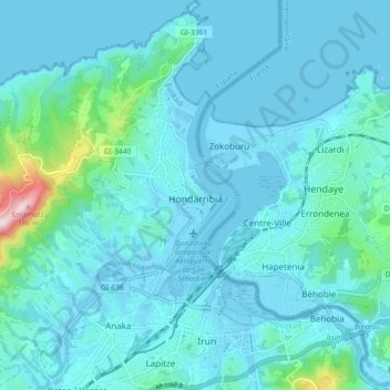
Name: Hondarribia/Fontarrabie topographic map, elevation, terrain.
Average elevation: 121 ft
Minimum elevation: -20 ft
Maximum elevation: 1,207 ft
Other topographic maps
Click on a map to view its topography, its elevation and its terrain.
Hondarribia
Spain > Autonomous Community of the Basque Country > Bidasoa Beherea / Bajo Bidasoa > Hondarribia
Hondarribia, Bidasoa Beherea / Bajo Bidasoa, Gipuzkoa, Autonomous Community of the Basque Country, Spain
Average elevation: 112 ft
Irun
Spain > Autonomous Community of the Basque Country > Bidasoa Beherea / Bajo Bidasoa
Irun, Bidasoa Beherea / Bajo Bidasoa, Gipuzkoa, Autonomous Community of the Basque Country, Spain
Average elevation: 535 ft