
Make a donation
Gear up for your next adventure:
As an Amazon Associate, this site earns from qualifying purchases at no extra cost to you.
Trevelin topographic map
Click on the map to display elevation.
Make a donation
Gear up for your next adventure:
As an Amazon Associate, this site earns from qualifying purchases at no extra cost to you.
Trevelin
Trevelin has a temperate oceanic climate (Köppen Cfb), but with a rainfall pattern similar to the Mediterranean climate (Köppen Csb). The climate is milder than that of other locations on the Argentine side of Northern Patagonia because of the low altitude and the direct exposure to Pacific winds. This microclimate allows for intensive agriculture, a rarity in the region where mid-summer frosts occur every year. Nighttime temperatures rarely drop below −10 °C (14 °F) and although snowfall is frequent, it does not cover the ground for long periods of time. Winters are stormy with frequent rain, sleet and snow while summers are cool, windy and relatively dry.
Make a donation
Gear up for your next adventure:
As an Amazon Associate, this site earns from qualifying purchases at no extra cost to you.
About this map
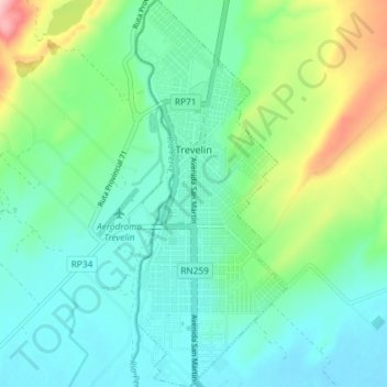
Name: Trevelin topographic map, elevation, terrain.
Average elevation: 1,322 ft
Minimum elevation: 1,165 ft
Maximum elevation: 1,785 ft
Make a donation
Gear up for your next adventure:
As an Amazon Associate, this site earns from qualifying purchases at no extra cost to you.
Other topographic maps
Click on a map to view its topography, its elevation and its terrain.