
Stalmine-with-Staynall topographic map
Interactive map
Click on the map to display elevation.
About this map
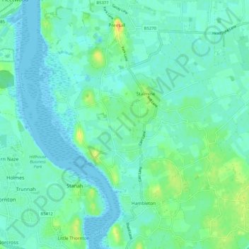
Name: Stalmine-with-Staynall topographic map, elevation, terrain.
Average elevation: 23 ft
Minimum elevation: 0 ft
Maximum elevation: 98 ft
Other topographic maps
Click on a map to view its topography, its elevation and its terrain.
Garstang
United Kingdom > England > Wyre > Garstang
Garstang, Wyre, Lancashire, North West England, England, PR3 1FA, United Kingdom
Average elevation: 148 ft
Inskip
United Kingdom > England > Wyre > Inskip
Inskip, Wyre, Lancashire, North West England, England, PR4 0SP, United Kingdom
Average elevation: 46 ft
Winmarleigh
United Kingdom > England > Wyre > Winmarleigh
Winmarleigh, Wyre, Lancashire, North West England, England, United Kingdom
Average elevation: 43 ft
Claughton
United Kingdom > England > Wyre > Claughton
Claughton, Wyre, Lancashire, North West England, England, PR3 0PN, United Kingdom
Average elevation: 223 ft
Claughton
United Kingdom > England > Wyre
Claughton, Wyre, Lancashire, North West England, England, United Kingdom
Average elevation: 328 ft