
Make a donation
Gear up for your next adventure:
As an Amazon Associate, this site earns from qualifying purchases at no extra cost to you.
Herscheid topographic map
Click on the map to display elevation.
Make a donation
Gear up for your next adventure:
As an Amazon Associate, this site earns from qualifying purchases at no extra cost to you.
Herscheid
Herscheid is located in the Ebbegebirge ("Ebbe Mountains"), a part of the Sauerland mountains. Altitudes in the municipality extend from 250m above sea level in the valley of the Schwarze Ahe up to the highest elevation, the 663.3 metres (2,176 ft) high Nordhelle. The municipality covers an area of 58.924 square kilometres (22.751 sq mi), of which 58% is forest and 33% is used agriculturally. Most of the area is protected as a nature reserve, the Naturpark Ebbegebirge.
Make a donation
Gear up for your next adventure:
As an Amazon Associate, this site earns from qualifying purchases at no extra cost to you.
About this map
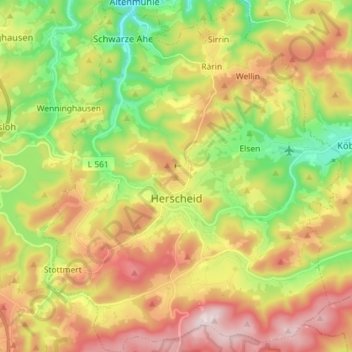
Name: Herscheid topographic map, elevation, terrain.
Average elevation: 1,447 ft
Minimum elevation: 810 ft
Maximum elevation: 2,178 ft
Make a donation
Gear up for your next adventure:
As an Amazon Associate, this site earns from qualifying purchases at no extra cost to you.