
Ichkeul topographic map
Interactive map
Click on the map to display elevation.
About this map
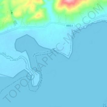
Name: Ichkeul topographic map, elevation, terrain.
Location: Ichkeul, RR 51 طج, Sidi Ameur, Bizerte Sud, Bizerte, Tunisie (37.16981 9.60074 37.20176 9.66609)
Average elevation: 36 ft
Minimum elevation: -20 ft
Maximum elevation: 558 ft
Other topographic maps
Click on a map to view its topography, its elevation and its terrain.
Oued Meradi
Oued Meradi, Sidi Mechreg, Sejnane, Bizerte, Tunisie
Average elevation: 400 ft
Menzel Abderrahmane
Tunisie > Bizerte > Menzel Abderrahmane
Menzel Abderrahmane, Menzel Abderrahmane Ouest, Menzel Jemil, Bizerte, 7035, Tunisie
Average elevation: 30 ft
Oued Zitoun
Oued Zitoun, Dhouaouda, Ghezala, Bizerte, Tunisie
Average elevation: 1,394 ft