
Camboulan topographic map
Interactive map
Click on the map to display elevation.
About this map
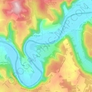
Name: Camboulan topographic map, elevation, terrain.
Average elevation: 807 ft
Minimum elevation: 486 ft
Maximum elevation: 1,293 ft
Other topographic maps
Click on a map to view its topography, its elevation and its terrain.
Château de Camboulan
France > Occitanie > Aveyron > Ambeyrac > Mas des Graves
Château de Camboulan, D 127, Mas des Graves, Ambeyrac, Villefranche-de-Rouergue, Aveyron, Occitanie, France métropolitaine, 12260, France
Average elevation: 751 ft