
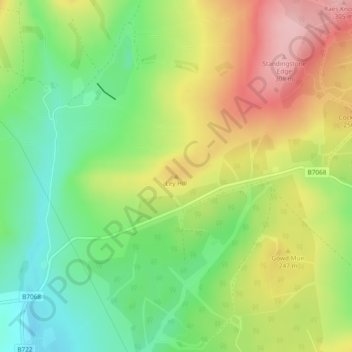
Ley Hill topographic map
Interactive map
Click on the map to display elevation.
About this map
Name: Ley Hill topographic map, elevation, terrain.
Average elevation: 702 ft
Minimum elevation: 453 ft
Maximum elevation: 1,010 ft
Other topographic maps
Click on a map to view its topography, its elevation and its terrain.
Sanquhar
United Kingdom > Scotland > Dumfries and Galloway
Sanquhar, Dumfries and Galloway, Scotland, DG4 6DJ, United Kingdom
Average elevation: 797 ft
Gillesbie
United Kingdom > Scotland > Dumfries and Galloway > Boreland
Gillesbie, Boreland, Dumfries and Galloway, Scotland, DG11 2LF, United Kingdom
Average elevation: 640 ft
Holywood
United Kingdom > Scotland > Dumfries and Galloway
Holywood, Dumfries and Galloway, Scotland, DG2 0RE, United Kingdom
Average elevation: 85 ft
Lockerbie
United Kingdom > Scotland > Dumfries and Galloway
Lockerbie, Dumfries and Galloway, Scotland, DG11 2EU, United Kingdom
Average elevation: 315 ft
Cairnryan
United Kingdom > Scotland > Dumfries and Galloway > Cairnryan
Cairnryan, Dumfries and Galloway, Scotland, DG9 8RB, United Kingdom
Average elevation: 210 ft
Drummore
United Kingdom > Scotland > Dumfries and Galloway
Drummore, Dumfries and Galloway, Scotland, DG9 9PY, United Kingdom
Average elevation: 118 ft