
Çınartepe Mahallesi topographic map
Interactive map
Click on the map to display elevation.
About this map
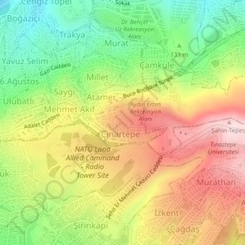
Name: Çınartepe Mahallesi topographic map, elevation, terrain.
Location: Çınartepe Mahallesi, Konak, Izmir, Aegean Region, Turkey (38.40595 27.17828 38.41125 27.18963)
Average elevation: 577 ft
Minimum elevation: 52 ft
Maximum elevation: 1,122 ft
Other topographic maps
Click on a map to view its topography, its elevation and its terrain.
Güneşli Mahallesi
Güneşli Mahallesi, Konak, Izmir, Aegean Region, Turkey
Average elevation: 299 ft
Yenigün Mahallesi
Yenigün Mahallesi, Konak, Izmir, Aegean Region, Turkey
Average elevation: 115 ft