
Lambermont topographic map
Interactive map
Click on the map to display elevation.
About this map
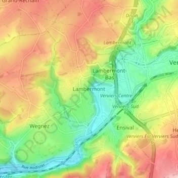
Name: Lambermont topographic map, elevation, terrain.
Location: Lambermont, Verviers, Liège, Wallonie, 4800, Belgique (50.56731 5.81508 50.60731 5.85508)
Average elevation: 722 ft
Minimum elevation: 446 ft
Maximum elevation: 1,030 ft
Other topographic maps
Click on a map to view its topography, its elevation and its terrain.
Lambermont Village
Belgique > Liège > Verviers > Verviers > Lambermont > Fiérain
Lambermont Village, Fiérain, Lambermont, Verviers, Liège, Wallonie, 4800, Belgique
Average elevation: 699 ft
Lambermont-Bas
Belgique > Liège > Verviers > Verviers
Lambermont-Bas, Verviers, Liège, Wallonie, 4800, Belgique
Average elevation: 728 ft
Cheval blanc
Belgique > Liège > Verviers > Verviers
Cheval blanc, Verviers, Liège, Wallonie, 4800, Belgique
Average elevation: 938 ft
Petit-Rechain
Belgique > Liège > Verviers > Verviers
Petit-Rechain, Verviers, Liège, Wallonie, 4800, Belgique
Average elevation: 840 ft