
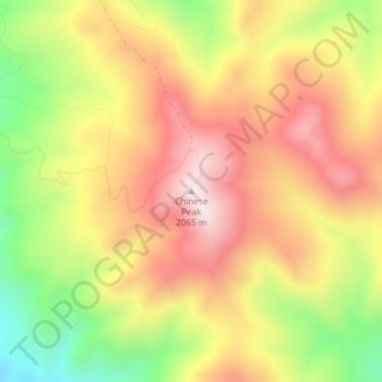
Chinese Peak topographic map
Interactive map
Click on the map to display elevation.
About this map
Name: Chinese Peak topographic map, elevation, terrain.
Average elevation: 6,004 ft
Minimum elevation: 5,043 ft
Maximum elevation: 6,781 ft
Other topographic maps
Click on a map to view its topography, its elevation and its terrain.
Snake River
United States of America > Idaho
Snake River, Washington County, Idaho, 83672, United States of America
Average elevation: 2,113 ft
Sawtooth National Forest
United States of America > Idaho > Rupert
Sawtooth National Forest, Sharon Court, Rupert, Minidoka County, Idaho, 83350, United States of America
Average elevation: 5,276 ft
Genesee
United States of America > Idaho > Genesee
Genesee, Latah County, Idaho, 83832, United States of America
Average elevation: 2,703 ft
Butte County
United States of America > Idaho
Butte County, Idaho, United States of America
Average elevation: 6,280 ft
Camas County
United States of America > Idaho
Camas County, Idaho, United States of America
Average elevation: 6,568 ft
Eagle Rock
United States of America > Idaho
Eagle Rock, Idaho County, Idaho, United States of America
Average elevation: 3,819 ft
Teton
United States of America > Idaho > Teton
Teton, Fremont County, Idaho, 83451, United States of America
Average elevation: 4,951 ft
Springston
United States of America > Idaho
Springston, Kootenai County, Idaho, 83833, United States of America
Average elevation: 2,365 ft