
土地灣村 To Tei Wan Village topographic map
Interactive map
Click on the map to display elevation.
About this map
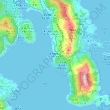
Name: 土地灣村 To Tei Wan Village topographic map, elevation, terrain.
Location: 土地灣村 To Tei Wan Village, 南區 Southern District, HK, RPC (22.20564 114.21714 22.24564 114.25714)
Average elevation: 154 ft
Minimum elevation: -7 ft
Maximum elevation: 1,010 ft