
Shawinigan topographic map
Interactive map
Click on the map to display elevation.
About this map
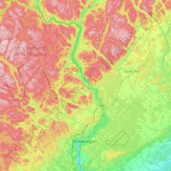
Name: Shawinigan topographic map, elevation, terrain.
Location: Shawinigan, Mauricie, Québec, Canada (46.45907 -73.17888 46.91975 -72.58373)
Average elevation: 699 ft
Minimum elevation: 62 ft
Maximum elevation: 1,522 ft
Other topographic maps
Click on a map to view its topography, its elevation and its terrain.
Shawinigan
Canada > Québec > Shawinigan
Shawinigan, Mauricie, Québec, G9N 1G6, Canada
Average elevation: 449 ft