
Rottweil topographic map
Interactive map
Click on the map to display elevation.
About this map
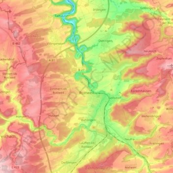
Name: Rottweil topographic map, elevation, terrain.
Average elevation: 2,126 ft
Minimum elevation: 1,611 ft
Maximum elevation: 2,513 ft
Other topographic maps
Click on a map to view its topography, its elevation and its terrain.
Schiltach
Germany > Baden-Württemberg > Landkreis Rottweil
Schiltach, Verwaltungsgemeinschaft Schiltach, Landkreis Rottweil, Baden-Württemberg, 77761, Germany
Average elevation: 1,929 ft
Schenkenzell
Germany > Baden-Württemberg > Landkreis Rottweil
Schenkenzell, Verwaltungsgemeinschaft Schiltach, Landkreis Rottweil, Baden-Württemberg, 77773, Germany
Average elevation: 1,978 ft
Oberndorf am Neckar
Germany > Baden-Württemberg > Landkreis Rottweil
Oberndorf am Neckar, Verwaltungsgemeinschaft Oberndorf am Neckar, Landkreis Rottweil, Baden-Württemberg, 78727, Germany
Average elevation: 2,018 ft
Schramberg
Germany > Baden-Württemberg > Landkreis Rottweil
Schramberg, Verwaltungsgemeinschaft Schramberg, Landkreis Rottweil, Baden-Württemberg, Germany
Average elevation: 2,316 ft