
Sandford topographic map
Click on the map to display elevation.
About this map
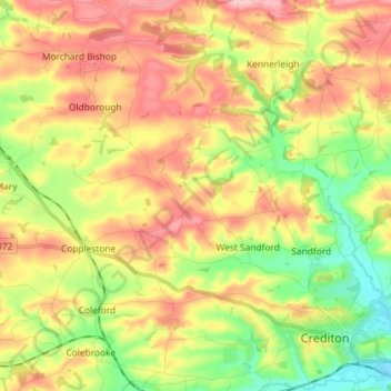
Name: Sandford topographic map, elevation, terrain.
Location: Sandford, Mid Devon, Devon, England, United Kingdom (50.79509 -3.76155 50.85097 -3.61659)
Average elevation: 374 ft
Minimum elevation: 118 ft
Maximum elevation: 646 ft
Other topographic maps
Click on a map to view its topography, its elevation and its terrain.
White Cross
United Kingdom > England > Devon > Mid Devon > Cheriton Fitzpaine
Average elevation: 430 ft
Bailey
United Kingdom > England > Devon > Mid Devon > Newton St. Cyres > Bailey
Average elevation: 299 ft