
Aghwar Janoobiyah Sub-District topographic map
Interactive map
Click on the map to display elevation.
About this map
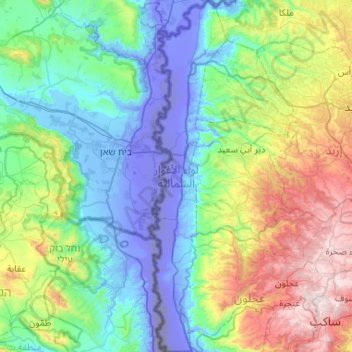
Name: Aghwar Janoobiyah Sub-District topographic map, elevation, terrain.
Average elevation: 837 ft
Minimum elevation: -1,086 ft
Maximum elevation: 4,088 ft
Other topographic maps
Click on a map to view its topography, its elevation and its terrain.
طبقة فحل
Jordan > Irbid > Aghwar Janoobiyah Sub-District
طبقة فحل, Aghwar Janoobiyah Sub-District, Aghwar Shamaliyah District, Irbid, Jordan
Average elevation: -167 ft